Matanog
Matanog | |
|---|---|
Municipalidad | |
 | |
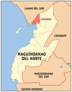
 Mapa de Maguindánao del Norte con Matanog resaltado | |
 | |
| Coordenadas: 7°28'N, 124°15'E | |
| Nación | Filipinas |
| Región | Maguindánao del Norte |
| Provincia | Maguindánao del Norte |
| Número de barangay | 8 |
| Gobierno | |
| • Type | consejo municipal |
| • Electorado | Error en la secuencia de órdenes: la función «getValue» no existe. votantes (9 Mayo 2022) |
| Superficie | |
| • Total | 146,50 km2 (56,56 sq mi) |
| Elevation | 328 m (1076 ft) |
| Populación (1 Mayo 2020) | |
| • Total | 36,034 |
| • Densidad | 0,25/km2 (0,64/sq mi) |
| • Hogares | 5,711 |
| Economía | |
| • Clase de ingresos | el ika cuatro clase de municipalidad |
| • Incidencia de la pobreza | Error en la secuencia de órdenes: la función «getValue» no existe.% (Error: fecha y hora no válidas.)[2] |
| • Ingresos | ₱ <strong4a4df3e5">Error (Error: fecha y hora no válidas.) |
| • Activos | ₱ <strong4a4df3e5">Error (Error: fecha y hora no válidas.) |
| • Pasivos | ₱ <strong4a4df3e5">Error (Error: fecha y hora no válidas.) |
| • Gastos | ₱ <strong4a4df3e5">Error (Error: fecha y hora no válidas.) |
| Huso horario | UTC+8 (PST) |
| Código postal | 9613 |
| PSGC | |
| Código telefonico | 64 |
| Lenguaje nativo | idioma maguindánao idioma maranao Tagalog |
| Website | http://www.matanog.gov.ph/ |
Matanog el ika cuatro clase de municipalidad na provincia de Maguindánao del Norte, Filipinas. Tiene este zona de 146.50 kilometro cuadrado.
Comporme del 1 Mayo 2020 censo este tiene papulidad de 36,034 personas y 5,711 hogares. El designada codigo postal 9613 y PSGC 153809000.
Barangay
revisa- Bayanga Norte
- Bayanga Sur
- Bugasan Norte
- Bugasan Sur (Poblacion)
- Kidama
- Sapad
- Langco
- Langkong
Demografía
revisa| Año | Populación | ±% p.a. |
|---|---|---|
| 1980 | 8300 | — |
| 1990 | 14 759 | +5.93% |
| 1995 | 16 018 | +1.55% |
| 2000 | 19 006 | +3.73% |
| 2007 | 36 319 | +9.34% |
| 2010 | 23 269 | −14.96% |
| 2015 | 29 770 | +4.80% |
| 2020 | 36 034 | +3.83% |
| Ref: Autoridad de Estadísticas de Filipinas[3][4][5][6] | ||
Referencias
revisa- ↑ «Province: Maguindanao». PSGC Interactive. Quezon City, Philippines: Philippine Statistics Authority. Consultado el Diciembre 17, 2016.
- ↑ «PSA Releases the 2021 City and Municipal Level Poverty Estimates» (2 Abril 2024).
- ↑ Census of Population (2015). "ARMM – Autonomous Region in Muslim Mindanao". Total Population by Province, City, Municipality and Barangay. Philippine Statistics Authority.
- ↑ Census of Population and Housing (2010). "ARMM – Autonomous Region in Muslim Mindanao". Total Population by Province, City, Municipality and Barangay. NSO.
- ↑ Censuses of Population (1903–2007). "ARMM – Autonomous Region in Muslim Mindanao". Table 1. Population Enumerated in Various Censuses by Province/Highly Urbanized City: 1903 to 2007. NSO.
- ↑ «Province of Maguindanao». Municipality Population Data. Local Water Utilities Administration Research Division. Consultado el Diciembre 17, 2016.
Enlaces externos
revisa- PhilAtlas.com
- Philippine Standard Geographic Code
- Local Governance Performance Management System
- www
.matanog .gov .ph
| Provincia de Maguindanao | |
| Buluan (cabecera) | |
| Municipalidad: | Ampatuan ▪ Barira ▪ Buldon ▪ Buluan ▪ Datu Abdullah Sangki ▪ Datu Anggal Midtimbang ▪ Datu Blah T. Sinsuat ▪ Datu Hoffer Ampatuan ▪ Datu Montawal ▪ Datu Odin Sinsuat ▪ Datu Paglas ▪ Datu Piang ▪ Datu Salibo ▪ Datu Saudi Ampatuan ▪ Datu Unsay ▪ General Salipada K. Pendatun ▪ Guindulungan ▪ Kabuntalan ▪ Mamasapano ▪ Mangudadatu ▪ Matanog ▪ Northern Kabuntalan ▪ Pagalungan ▪ Paglat ▪ Pandag ▪ Parang ▪ Rajah Buayan ▪ Shariff Aguak ▪ Shariff Saydona Mustapha ▪ Upi del Sur ▪ Sultan Kudarat ▪ Sultan Mastura ▪ Sultan sa Barongis ▪ Talitay ▪ Talayan ▪ Upi |
| Ciudad: | Cotabato |