Valle de Cagayán
Valle de Cagayán | |
|---|---|
Región | |
 | |
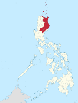
 Mapa de Filipinas con Valle de Cagayán resaltado | |
 | |
| Coordenadas: 17°37'N, 121°43'E | |
| Nación | Filipinas |
| Región | Filipinas |
| Cabecera | Tuguegarao |
| Gobierno | |
| • Electorado | Error en la secuencia de órdenes: la función «getValue» no existe. votantes (9 Mayo 2019) |
| Superficie | |
| • Total | 28,228,83 km2 (10,899 sq mi) |
| Populación (1 Mayo 2020) | |
| • Total | 3,685,744 |
| • Densidad | 0,13/km2 (0,34/sq mi) |
| • Hogares | 789,269 |
| Huso horario | UTC+8 (PST) |
| PSGC | |
| ISO 3166 | PH-02 |
| Lenguaje nativo | Pamplona Atta Arta Dupaningan Agta idioma batán Isnag Itawis ilocano Faire Atta |
Valle de Cagayán na región de Filipinas, Filipinas. Tiene este zona de 28,228.83 kilometro cuadrado. Comporme del 1 Mayo 2020 censo este tiene papulidad de 3,685,744 personas y 789,269 hogares. El designada PSGC 020000000. Su capital es Tuguegarao.
Demografía
revisa| Año | Populación | ±% p.a. |
|---|---|---|
| 1903 | 295 211 | — |
| 1918 | 348 332 | +1.11% |
| 1939 | 600 151 | +2.62% |
| 1948 | 669 006 | +1.21% |
| 1960 | 1 035 750 | +3.71% |
| 1970 | 1 462 723 | +3.51% |
| 1975 | 1 665 245 | +2.63% |
| 1980 | 1 919 091 | +2.88% |
| 1990 | 2 340 545 | +2.01% |
| 1995 | 2 536 035 | +1.51% |
| 2000 | 2 813 159 | +2.25% |
| 2007 | 3 051 487 | +1.13% |
| 2010 | 3 229 163 | +2.08% |
| 2015 | 3 451 410 | +1.28% |
| 2020 | 3 685 744 | +1.30% |
| Ref: Autoridad de Estadísticas de Filipinas[3][4][5][6] | ||
Subdivisión política
revisaReferencias
revisa- ↑ «Province:». PSGC Interactive. Quezon City, Philippines: Philippine Statistics Authority. Consultado el Diciembre 17, 2016.
- ↑ «2021 Full Year Official Poverty Statistics of the Philippines» (15 Agosto 2022).
- ↑ Census of Population (2015). "Region II (Cagayan Valley)". Total Population by Province, City, Municipality and Barangay. Philippine Statistics Authority.
- ↑ Census of Population and Housing (2010). "Region II (Cagayan Valley)". Total Population by Province, City, Municipality and Barangay. NSO.
- ↑ Censuses of Population (1903–2007). "Region II (Cagayan Valley)". Table 1. Population Enumerated in Various Censuses by Province/Highly Urbanized City: 1903 to 2007. NSO.
- ↑ «Province of». Municipality Population Data. Local Water Utilities Administration Research Division. Consultado el Diciembre 17, 2016.